Trekking the Annapurna circuit – 14 Days Itinerary
We’ve just finished Trekking the Annapurna circuit in 14 days and decided to share with you our notes, highlights, photos, gear, memories and the things we used and helped us a lot to finish this trek in record time as beginner trekkers, hope you find these informations useful.
List of Things we are recommending you to have before Trekking the Annapurna circuit in 14 days:
The highlighted word will take you to Amazon from where you can buy them. We used ALL the products that are linked here.
- Clothing:
- Big backpack
- Smaller backpack for your personal stuff (If you are using a porter and for short sight seeing)
- Two pairs of wool long socks
- Five pairs of light trekking socks
- Fast drying underwear
- One pair of shorts
- One pair of light trekking pants (Female pants)
- One pair of warm winter pants (Female pants)
- Two technical long/short sleeve shirts (dry fit, fast drying)
- One fleece sweater for trekking
- Winter jacket/Dawn jacket
- Rain coat – You can find cheaper than this, but we still use it
- Comfortable “walked in” trekking boots – Dado have these ones, but it turned out that he didn’t need them since there was no show. He did find better use of them when we hiked the Langtang trek in January.
- Trainers (for village exploration)
- Flip flops (you gonna need them to rest your feet after trekking and for the bathrooms)
- One fleece sweater for cold mountain evenings
- Thermal underwear, top and bottom
- Cap – That can protect your neck!
- Winter hat
- Scarf, Buff or skiing mask
- Gloves
- Sunglasses
- Fast drying towel
- Something to sleep in/or you can use one of the shirts – We slept in our long sleeve fleece and thermal pants in the high mountain guest houses, in the lower ones we used t-shirt and shorts.
- Toiletries – Besides the basic necessary tools you are taking with you everywhere (shampoo, tooth paste and brush, shower gel, cream), you should also bring:
- Wet wipes
- Sun cream
- Toilet paper
- Antibacterial hand gel (Detol)
- Nail clipper
- Lip balm
- Tropical anti mosquito spray
- Carry a Medical kit while Trekking the Annapurna Circuit:
- Pain killers
- Something for diarrhea
- Pills against cold
- Nose spray
- Altitude pills
- Plasters
- Anything about blisters (needle, compeed)
- Sore throat drops
- Cream for muscle pain (we use a cream called “horse cream”)
- Pills and other medicaments you usually use
- Other necessary thing you must have while trekking the Annapurna Circuit:
- Water purifying tabs – More expensive, but HIGHLY recommended (above 3000m the bottle water is way too expensive)
- Water bottle – 1L
- Head lamp (for early morning trekking and the power cuts)
- Small package of washing powder for your laundry
- Strings for hanging clothes
- Lighter and candles
- Swiss knife (with all the additions)
- Pillow case – The pillows in the Guest house are not always in the cleanest and best condition (optional)
- Pens or Pencils (for you and for give a way to local kids)
- Note book (You want to make notes of your adventure)
- Camera
- Snacks (Protein bars or biscuits for the time between meals on the trek)
- Batteries, power bag
- Phone (Emergency, internet, alarm, clock, music, photos … )
- Book (optional)
- Hooks (optional)
- Map
- Guide book
This is Trekking the Annapurna circuit – 14 Days Itinerary
Day 1 – The bus ride
15.08.2014
Drive with a local bus from Gongabu Bus station, Kathmandu to Besisahar (Altitude: 760m)
- Bus ticket: 650rps (6.3$)
- Accommodation: Superview Guest House – Not recommending this guest house because of few reasons, the rooms and the bathrooms are below basic level, the cleanness is not their strength even in the kitchen, you are basically passing trough the staff who is washing the dishes and preparing your meal.
- The town/village: Not much to see, but as you walk down the street on both sides there are shops where you can buy all the necessary trekking equipments and toiletries in case you’ve forgotten something.
Day 2 – Beginning the Annapurna circuit trek
16.09.2014
Trekking from Besisahar (760m) to Syange (1100m)
- Distance: 20km with shortcuts
- Duration: 7h
- Elevation: 340m +
- Accommodation in Syange: Waterfall Guest House – Definitely recommending this hotel, decent rooms with attached bathroom and hot water, tasty food, great view from the roof top with the sound of a waterfall. Wi Fi and charging inlets are available in the lodge.
- Food:
- Breakfast in Besisahar: Tibetan bread with cheese plus omelet and black tea.
- Lunch in a restaurant along the way: Noodle soup plus Achar and fresh chilly peppers.
- Dinner at Waterfall Guest House: Dal Bhat and a hot masala tea.
- Highlights: From the very beginning of the trek in Besisahar you’re gonna be surrounded by green mountains decorated with waterfalls, bamboo and banana trees, you’ll have to cross some small springs along the trek barefoot and thats how you’ll experience the cold Himalayan water.
While trekking the Annapurna circuit you’ll be accompanied by big colorful butterflies and dragonflies, and also you will be warm greeted by the locals with their famous “Namaste“.
We can say that this is one of the most easiest part of the trail and its a good conditioning for the following days, because you are walking for more that 6 hours in a muddy and rocky road, also you should expect to see many jeeps and motor bikes because when you are not walking on the shortcuts, you are using the “main” road that is connecting the villages.
You are passing by a hydro power station in the 5 hours of the trek which can be disturbing and thats why many people choose to take the jeeps to Syange and start their trekking from there.
- Landscape: Rice fields, Rain forest, river and waterfalls.
- Climate: Hot and high level of humidity.
- Clothing: Shorts and T-Shirts, hat, sunglasses, light socks.
- Animals: Water buffalos, butterflies, chickens and goats.
- Difficulty: 4 of 10
Important Tips: Drink lots of water, use sun cream, have a spare t-shirt and wear hat & sunglasses at all times. Make sure your rain coat is at hand in case of showers and heavy rain, because September is still part of the monsoon season.
Photography tips: Amazing green landscapes, mountains and waterfalls raising above the powerful river Marsyangdi which is paradise for nature photographers.
We used a GoPro to capture the scenery because of its wide angle lens, also the iPhones helped us for some quick landscape shots.
You’re gonna meet many locals along the way to Syange, the people and the villages are so inspiring for travel, portrait and documentary photographers.
We used Canon 60D with 50mm f1.4 lens for capturing the faces of the locals.
Day 3 – Welcome to Manang
17.09.2014
Trekking from Syange (1100m) to Dharapani (2000m)
- Elevation: 900m +
- Duration: 8.5 h
- Distance: 16 km with shortcuts
- Accommodation in Dharapani: Tashi Delek Hotel – Lovely staff working in this place, we remember the young girl named Maya being friendly and smiling at us all the time. The food was nice, the rooms very pretty basic with no inlets and the bathrooms were hard core, dirty, below basic with an outdoor tap and from here on you can forget the English toilet.
- Food:
- Breakfast in Syange: Tibetan bread with honey plus two boiled eggs and black tea.
- Lunch in the “Riverside” family run restaurant in Taal: Dhal Bat with Mushrooms and black tea.
- Dinner at Dharapani: Steamed Veggie Mo:Mo’s and Veggie Spring Roll.
- Highlights: Used to the easy walking from the previous day we started the trek from Syange to Dharapani pretty optimistic. We passed the first hanging bridge and for the first time we put our feet on a “goats” trail.
Humidity, heat, slippery rocks, narrow paths, bushes, insects and small springs were just few of the things that will make trekking the Annapurna circuit even more difficult.
Followed by light showers along the trek we made it to the river village of Taal where we had our lunch, in the “Riverside” family restaurant we had the best Dal Bhat in Nepal.
Well fed and with rested feet we were again on our path towards the village of Dharapani where we were about to spend the night.
- Landscape: Rain forest, river, cliffs, many waterfalls, grey sandy river bank at Taal.
- Climate: Hot and high level of humidity in the day and cold evenings.
- Clothing: Shorts and T-Shirts, hat, sunglasses, light socks.
- Animals: Monkeys, Caterpillars, Eagle, Falcon, Water buffalos, butterflies, chickens and goats.
- Difficulty: 7 of 10
Important Tips: Be prepared for an hour and half climbing after the first hanging bridge you gonna pass if you want to use the shortcut to the village of Taal.
These is one difficult climb so make sure that you have a good energetic breakfast. You probably wanna start using the purifying tablets because the bottled water is getting expensive plus buying bottle water in the mountains is not good for the environment because the locals/shops/restaurants are disposing the garbage in the nature.
Drink lots of water, use sun cream, have a spare t-shirt and wear hat & sunglasses at all times. Make sure your rain coat is at hand in case of showers and heavy rain.
Have a light sweater also because of the cold evening breeze.
Photography tips: If you are a photographer and you have tele lens with you, make sure its attached on the body and be ready to make some shots of eagles and falcons.
The landscapes are amazing with many waterfalls and because you are on a goats trail, on your left side you will have an open view towards the mountains, so i would recommend you to have the tripod by hand so you can make some beautiful and wide landscape shots.
Phone photographers will also make some nice shots while trekking the Annapurna circuit because of the open view. Portraits lovers will do lots of shots while in the village of Taal and Dharapani because of the local kids that can be found there.
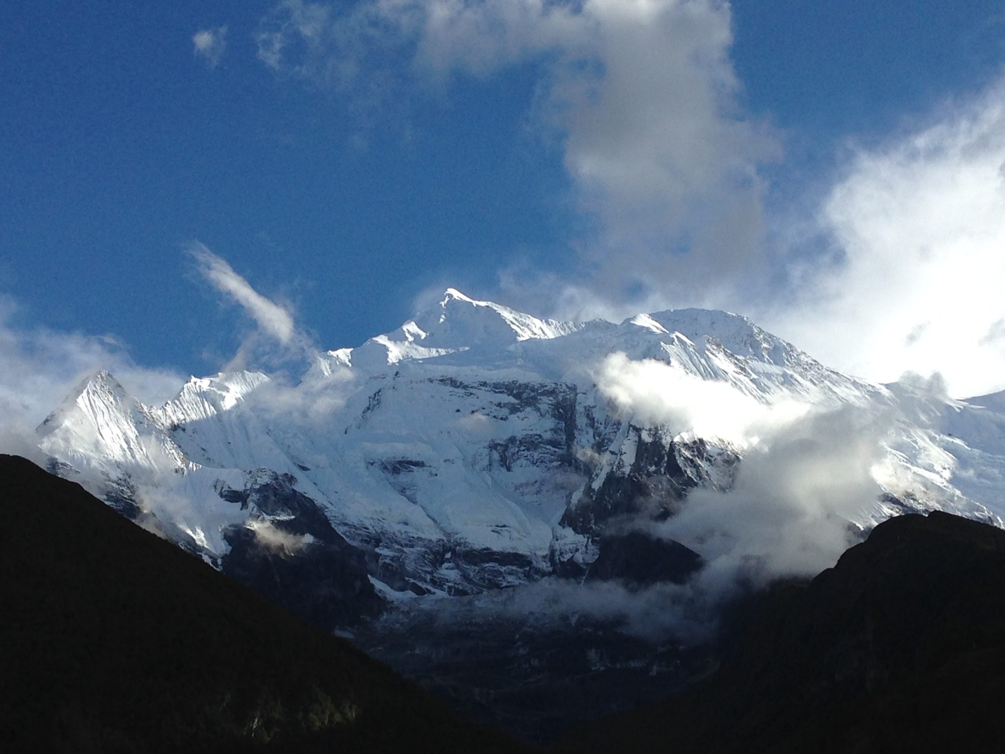
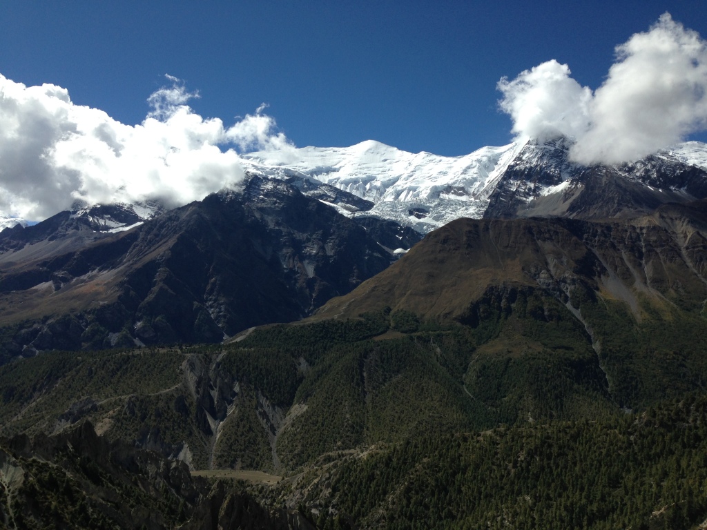
Day 4 - Glimpse of Manaslu while trekking the Annapurna circuit
18.09.2014
Trekking from Dharapani (2000m) to Chame (2600m)
- Elevation: 600m +
- Duration: 5.5 h
- Distance: 14 km with shortcuts
- Accommodation in Chame: Trekkers Holiday - Place where we first experienced how it feels to use a shower that works on gas. The hotel is typical Tibetan house with polite and friendly staff, the rooms are clean and they have the smell of sauna because of the wooden interior. The kitchen and the lodge are clean and the food is tasty, make sure to try the Tibetan bread.
- Food:
- Breakfast in Dharapani: Tibetan bread with jam and honey, chapati plus two boiled eggs and black tea.
- Lunch in restaurant in the middle of the road towards Chame: Cheese Mo:Mo's and Veggie Curry.
- Dinner at Chame: Dal Bhat and tea.
- Highlights: The view of the Manaslu range and the Peak Annapurna II brought back our energy. Walking in a forest with mixed flora, where the pines and the bamboo trees are creating one unique Himalayan eco system. We met many new trekkers from all around the world. Laugh and chat was heard from everywhere, until we needed to cross a river which water was freezing cold and changed our mood.
- Landscape: White peaks in the distance, less waterfalls and more pine trees on the nearby hills and mountains.
- Climate: Warm but not humid anymore. When in the forest it can be chilly.
- Clothing: Shorts, T-Shirt, long sleeve technical t-shirt, hat, sunglasses, light socks.
- Animals: Lizards, butterflies, chickens, horses and a funny looking bird which we still cannot identify.
- Difficulty: 6 of 10
Important Tips: It is time for the technical t-shirts because of the chilly weather in the forest. The evenings are cold and make sure your sweater is out of the big backpack. Pay attention on the trail or be close to the guide, because the paths in the forest can be confusing.
Photography tips: Not the favorite day for the photographers because of the dense forest, unless you are a macro photography lover. You'll be surrounded by insects and interesting high altitude plants that can be seen only on the Himalayas.
Day 5 - The Apple Road
19.09.2014
Trekking from Chame (2600m) to Pisang (3200m)
- Elevation: 800m +
- Duration: 5 h
- Distance: 16 km with shortcuts
- Accommodation in Pisang: Hotel Utse - Guest house with outdoor shower which is not well isolated and you need to pay 100rps for the hot water, we used our sweaters to cover the pillows because they didn't looked so clean. The bathrooms were kinda dangerous for the germophobics but that was expected cause we were now in the high mountains. The food was OK, nothing special. We won't recommend this hotel because there are many others around and you can look for a better accommodation upon arrival. Also they are charging 100rps for charging your phones/cameras to 100%.
- Food:
- Breakfast in Chame: Tibetan bread with jam and honey plus two boiled eggs and black tea.
- Lunch in worst restaurant that we visited along the trek: Dal Bhat.
- Dinner at Pisang: Veggie & Cheese Mo:Mo's
- Highlights: There is a beautiful Buddhist temple above the old village of "Upper Pisang" which is few minutes walk from "Pisang". The temple is the first you gonna see when doing this trek, its still under renovation and you can donate some money for the construction. As we were walking towards the village we passed by many apple farms, we bought few and the taste is still in our heads, fresh and homegrown, om nom nom. There is a different price for tourists and different for locals, so make sure that your guide buy them for you, or if you are traveling alone ask somebody to do that for you.
- Landscape: You can see the white peaks more often now and you will be surrounded by pine trees and dense forests.
- Climate: Strong sun and cool breeze.
- Clothing: Shorts, T-Shirt, long sleeve technical t-shirt, hat, sunglasses, light socks.
- Animals: Eagles and cows.
- Difficulty: 6 of 10
Important Tips: As you go higher the sun gets stronger and burns your skin, so make sure you use at least 30+ sun cream. Stick to the guide and follow the trail, cause of the dense forest you can be easily lost.
Photography tips: Time for some cultural, street and documentary photography. The old village "Upper Pisang" is offering some traditional style houses which are interesting for people who love to take shots of doors, windows and architecture.
In the temple you will see monks reading the holy letters and people praying to the Buddha, so it will be fun to capture some of those moments.
For the wildlife photographers the eagles will be your target definitely. Yes, Trekking the Annapurna circuit is amazing for these type of photographers.
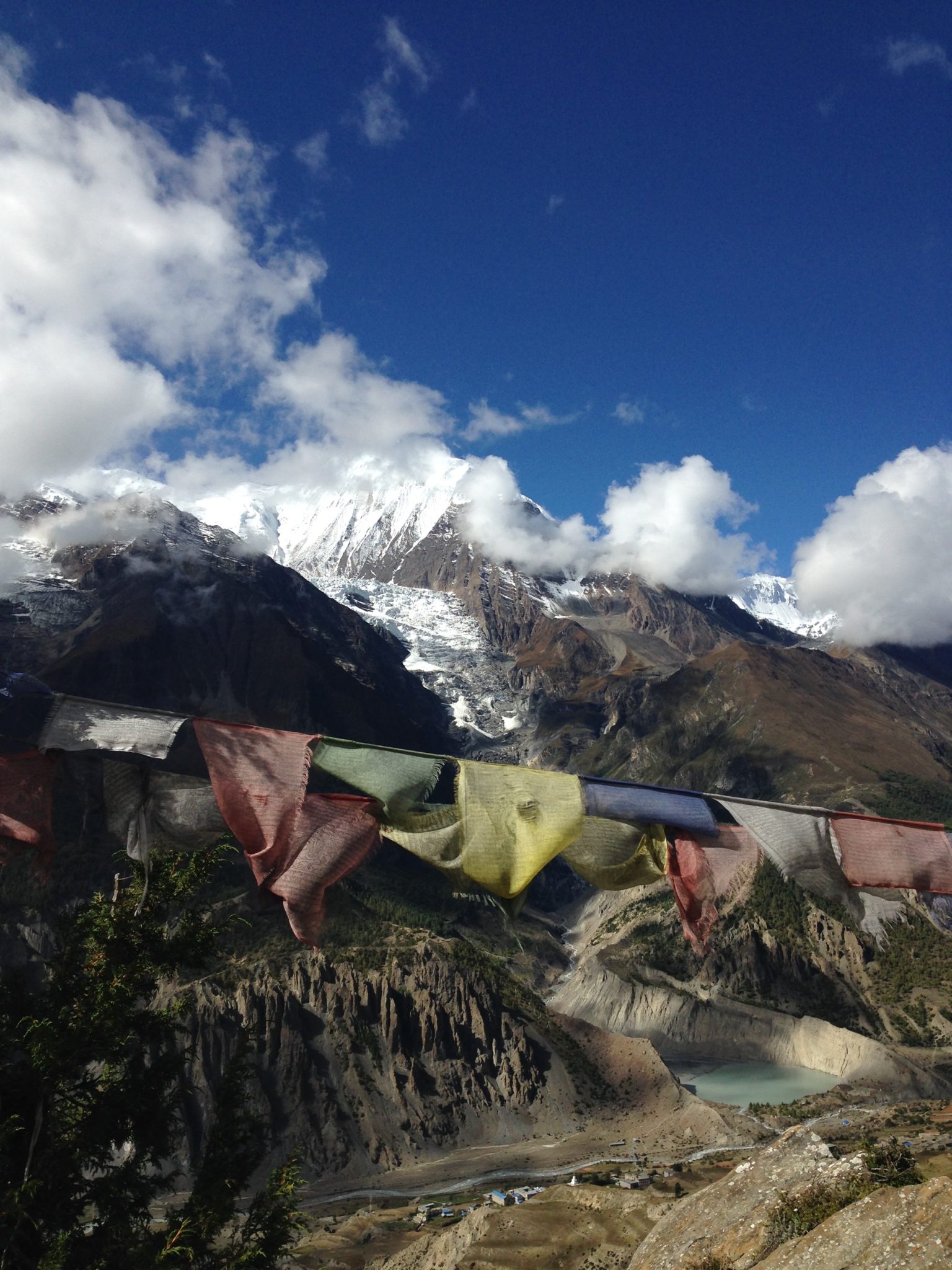
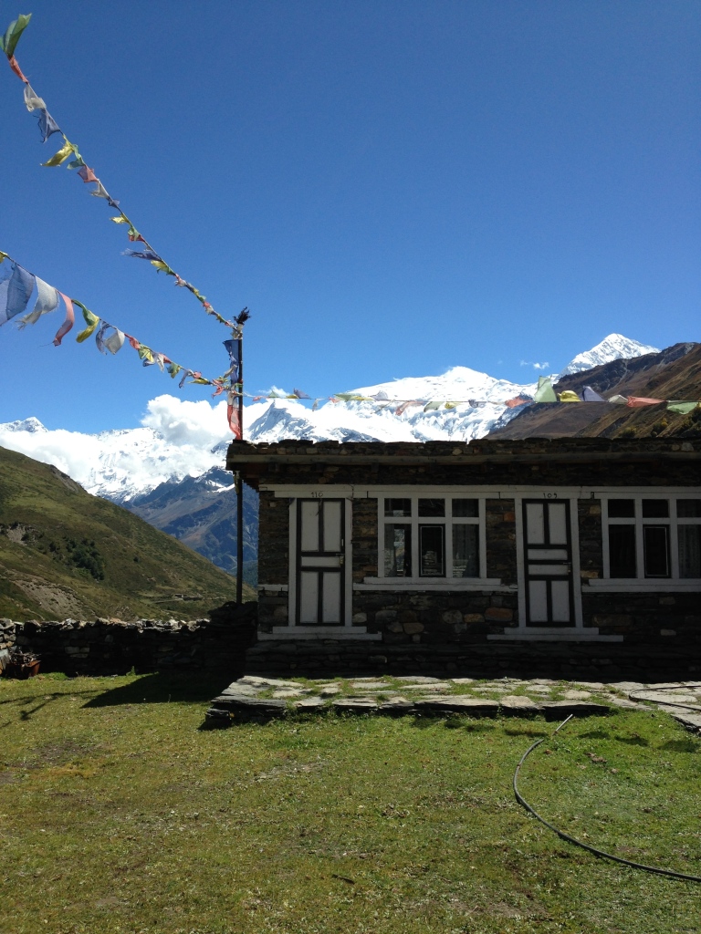
Day 6 - From Gangapurna with love
20.09.2014
Trekking from Pisang (3200m) to Manang (3550m)
- Elevation: 350m +
- Duration: 3.5 h
- Distance: 13 km with shortcuts
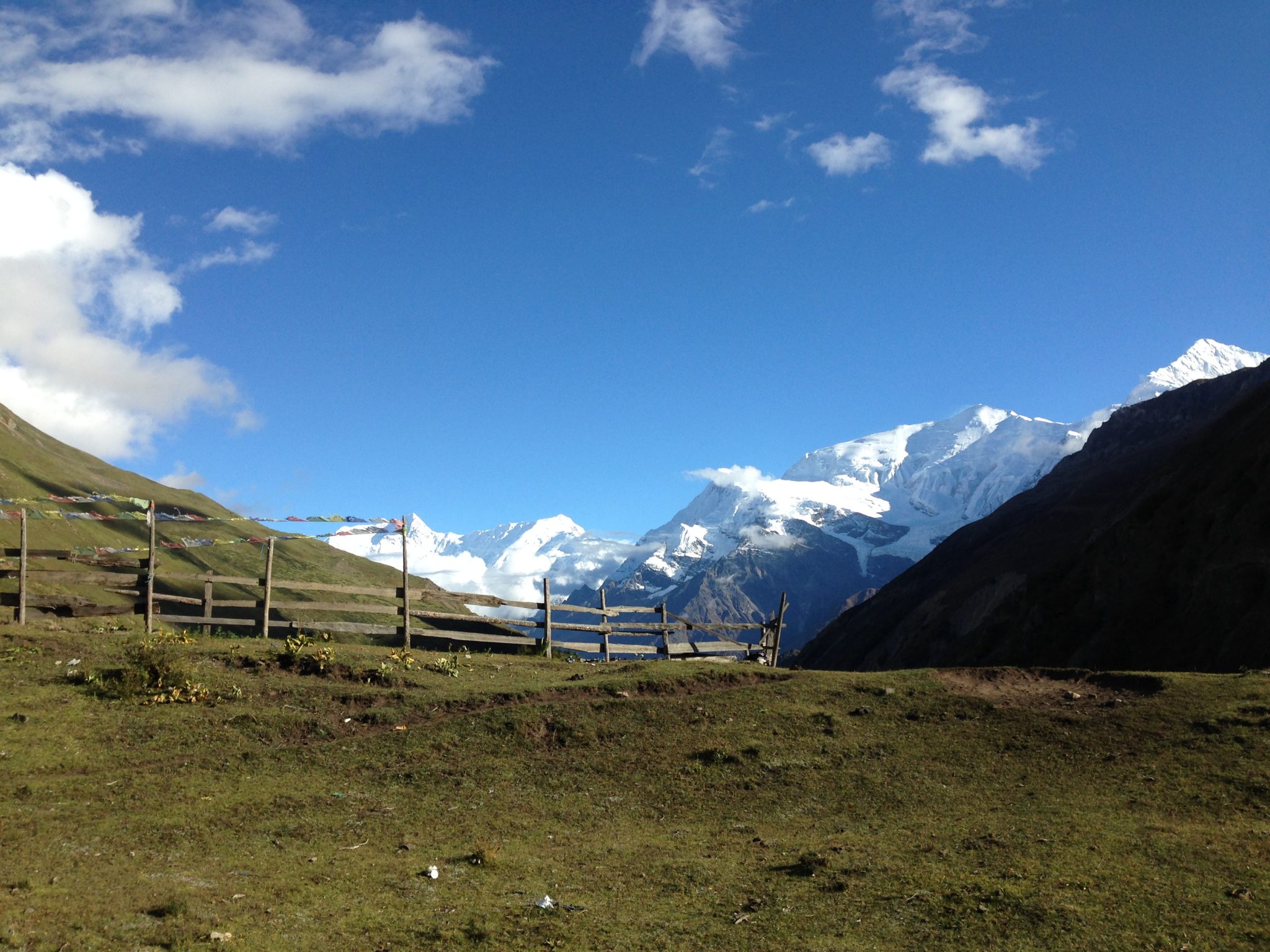
- Accommodation in Manang: Hotel Manang - Warm Guest House where we had the best room which is on the end on the second floor. With the magnificent view towards the Gangapurna peak our mornings will be moments to remember.
The bathrooms were decent, the rooms are clean, the garden in the middle is well maintained and the food is delicious, must try the apple pie.
Manang is a big village where you can find many shops and hotels, restaurants and crew if you want to continue the rest of your trip with someone more experienced. There are porters, guides and horses for the people who don't want to wast their feet.
In the village there is two cyber cafes which are pretty expensive, we payed 6$ for half an hour, in that time we managed to send only two messages on Facebook because the connection is desperate. - Food:
- Breakfast in Pisang: Tibetan bread and cheese pancake.
- Lunch in Manang: Chow mien & Potato curry
- Dinner at Manang: We slept 🙂
- Highlights: This was one of the easiest days we had since we started trekking the Annapurna circuit. The landscape was fascinating as always and the weather was sunny with not a single cloud on the sky.
We basically singed our way to Manang, hanging with other trekkers this was our "being social day". We were impressed by the beautiful garden in the hotel where we napped for some time and had the lunch on the grass.
Because we were among the first to arrive at the village and it was just minutes after noon, we decided to take the short walk to the Gangapurna lake where the water was freezing and the water was white because of the limestone. Overall, beautiful "Walk in the Nature" day.
- Landscape: Rocky cliffs and not so much trees as you approach Manang.
- Climate: Strong sun and cool breeze.
- Clothing: Shorts, long sleeve technical t-shirt, hat, sunglasses, light socks.
- Animals: Eagles and falcons.
- Difficulty: 4.5 of 10
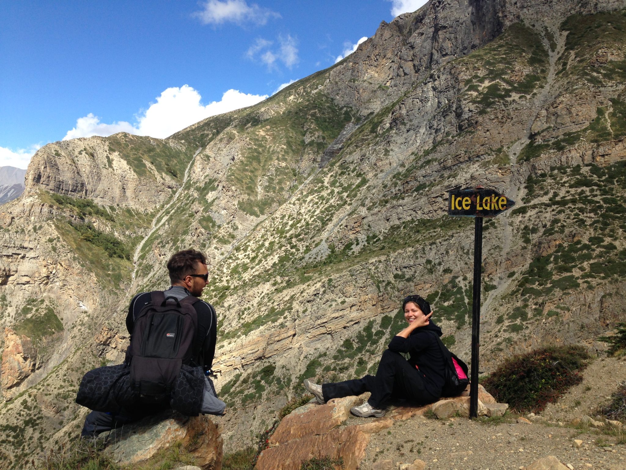
Important Tips: Manang will be the village where you gonna have your acclimatization day, but that doesn't mean that you need to sleep all the time, put your boots on and explore.
Our guide was pretty experienced and made everything so we don't feel altitude sickness while on the trek. The day we arrived we went to the Gangapurna lake and the evening we went to bed early because the next day when all the other trekkers were chilling we went to climb to the second highest lake on the Himalayas, the Ice lake which is 4635m high, more than 1000m climbing from Manang.
This was the hardest day in our lives! It is there where we first felt the high altitude pressure, headache and breathing difficulties, but our guide said that it was good to make a high altitude climbing and than go back to the acclimatization point for our system, because it will get use to the changes and we will have no problems for the Thorung La pass.
Photography tips: You will have some amazing landscapes and lakes capes if you visit the lake Gangapurna. The combination of the lake and the peak Gangapurna is amazing.
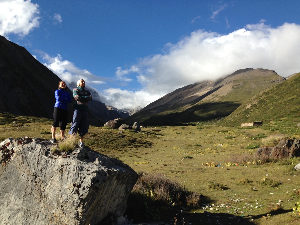
Day 7 - Day for chilling ... or not!
21.09.2014
Climbing from Manang (3550m) to the ICE LAKE (4800m)
- Elevation: 1250m +
- Duration: 3.5 h up - 3 h down
- Distance: 16 km
- Accommodation in Manang: Hotel Manang (Read from the previous day)
- Food:
- Breakfast in Manang: Tibetan bread and apple pancakes.
- Lunch in Manang: Dal Bhat
- Dinner at Manang: French Fries & Garlic soup
- Highlights: The most difficult but also amazing day of our adventure. We were expecting some easy climbing because this is the acclimatization day, but our guide pushed us to the limit. We were basically making 10 steps and getting our breaths for 5 minutes as we were approaching the lake.
When we arrived at the top we said that all the struggle was worth it. We could see the Annapurna and Gangapurna peaks, the mist hid some other white mountains but what we saw was enough.
There are two lakes up there but only the second one has the name "Ice Lake", we sat on the shore to enjoy the view and to have our Chapati with omelet as a brunch.
We touched the water which we expected to be ice cold, but the water was warm. The moment you pull out the hand from the lake and the cold wind touches your skin, you have the feeling that an ice cube is forming around the palm. Beautiful, clean, green grass, white peaks, with one word "Paradise".
The way back was the difficult part, dry muddy, narrow, steep and dangerous trail is what you need to walk on to get to Manang. We would take the climbing anytime, but only if there is another way back down.
- Landscape: Rocky cliffs, White peaks, green grass, lakes and rivers.
- Climate: Strong sun and cool wind.
- Clothing: Thermal underwear, long sleeve technical t-shirt, winter hat, sunglasses, winter long socks, winter pants, boots, gloves, winter jacket, scarf.
- Animals: Yaks, Deers, Eagles and falcons.
- Difficulty: 10+ of 10
Important Tips: Wear all the winter cloths you have, don't forget the gloves and the scarf. Get something to eat because you will be starving when you get to the lake. Have at least 2L water with you. Expect dangerous climbing up and hiking down. The most amazing scenery while Trekking the Annapurna circuit is seen from here.
Photography tips: White peaks, rocky cliffs, rivers, lakes, green scenery, mist, clouds, eagles, falcons, deers, yaks, basically everything that landscape and wildlife photographer is dreaming off. Prepare all the cameras you have!
Day 8 - Try the Muffins at Valeri's while Trekking the Annapurna Circuit
22.09.2014
Climbing from Manang (3550m) to Yak Kharka (4000m)
- Elevation: 450m +
- Duration: 4.5h
- Distance: 10 km
- Accommodation in Yak Kharka: Himalayan View Guest House - Out of the village of Yak Kharka is the lonely guest house which is offering the best view towards the Annapurna II.
There is no shower so you will need to use the water barrel in the yard if you want to wash yourselves. Make sure you have your sleeping bags if you are spending the night here cause it is very cold in the night, the structure is not well constructed and there is always a breeze in the rooms. - Food:
- Breakfast in Manang: Tibetan bread and boiled potatoes.
- Lunch in Yak Kharka: Dal Bhat
- Dinner at Yak Kharka: Tomato soup, Potato curry & Veggie fried potatoes.
- Highlights: We must say that the place we stopped for a tea "At Valeri's" as we called it was the highlight of the day. We had the best muffins ever (80rps per piece) we sat at the roof top and had the best view towards the Annapurna Peaks and the Gangapurna.
That day we saw a helicopter rescue just before we reach the Yak Kharka village, an Israeli guy had a altitude sickness and he needed immediate medical help.
- Landscape: Rocky cliffs, White peaks, bushes...
- Climate: Strong sun and breeze.
- Clothing: T-shirt, Shorts, light sweater.
- Animals: Yaks and horses.
- Difficulty: 6 of 10
Important Tips: Even if the time is sunny and warm, make sure that the sweater is at hand, weather can change in a second in the mountains. Make sure you stop for a short break at the French/Nepali Guest house and try the muffins.
Photography tips: There are not many people along the road, so make sure that you have your "landscape" lens set on the camera.
Day 9 - Entering into Mordor
23.09.2014
Trekking from Yak Kharka (4000m) to Thorung Phedi (4400m)
- Elevation: 400m +
- Duration: 3.5h
- Distance: 10 km
- Accommodation in Thorung Phedi: New Thorung Phedi G. House - Nice and clean guest house, when you remember that you are on 4400m above sea level, the accommodation will look like the Four Seasons.
Clean toilets if you are accommodated in the upper part (the guest house is basically a row of rooms, like garages. There are two rows, upper and lower).
The food is tasty and the dining room is traditional. Bellow there is one other Guest house that is ran by a Nepali guy and his western girlfriend. This place is made for the westerners and its more expensive. - Food:
- Breakfast in Yak Kharka: Omlet, Toast, Honey.
- Lunch in Thorung Phedi: Spring Roll, Mo: Mo's, French Fries.
- Dinner at Thorung Phedi: Dal Bhat.
- Highlights: Those who have watched "Lord of the rings" knows what Mordor means, for those who don't, it is a place only with rocks and mist where evil is dominating. So, trekking the Annapurna circuit this day we didn't experience any evil but we had some difficult climbing, all the time along the road we were surrounded by mist and rocks.
- Landscape: Rocky cliffs, White peaks, dry land.
- Climate: Strong sun and breeze.
- Clothing: Shorts, light sweater.
- Animals: Yaks, Eagles and horses.
- Difficulty: 7 of 10
Important Tips: Many of the trekkers are skipping this "lower camp" and are continuing their trek to the "upper camp".
We asked our guide why we are not going with the other groups, he said that it is not recommended for people that are not used to high altitude to spend the night above 5000m.
He also said that tomorrow the trekkers from the upper camp will be tired and with altitude sickens because they will have headaches and pressure problem during the night, except those who are used to the high altitude.
And it was true, we and 3 other groups spent the night in the lower camp and the next day we caught up with the groups from the upper camp and even reached the Thorung La pass before them.
Photography tips: If you are time-lapse lover this is the day for you. The clouds are all the time covering and uncovering the rocks and white peaks which is amazing for time lapse videos. They are like waves hitting on the shore rocks, but very very fast.
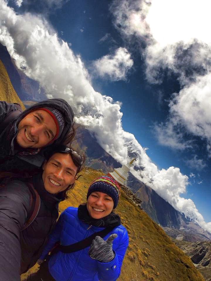
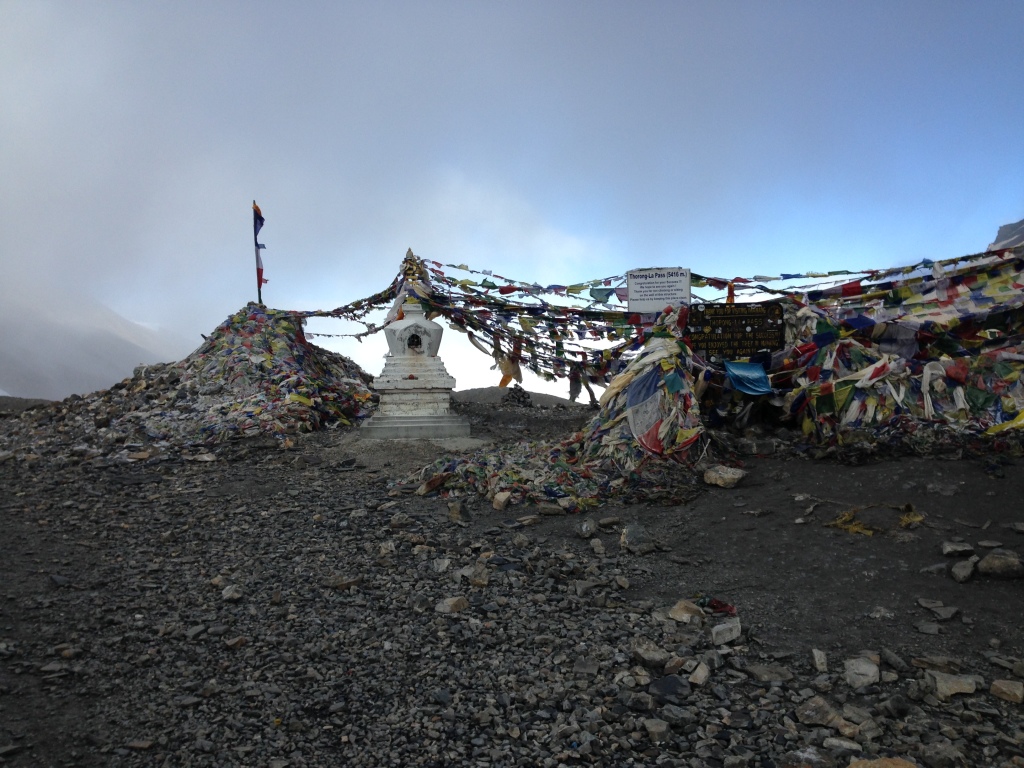
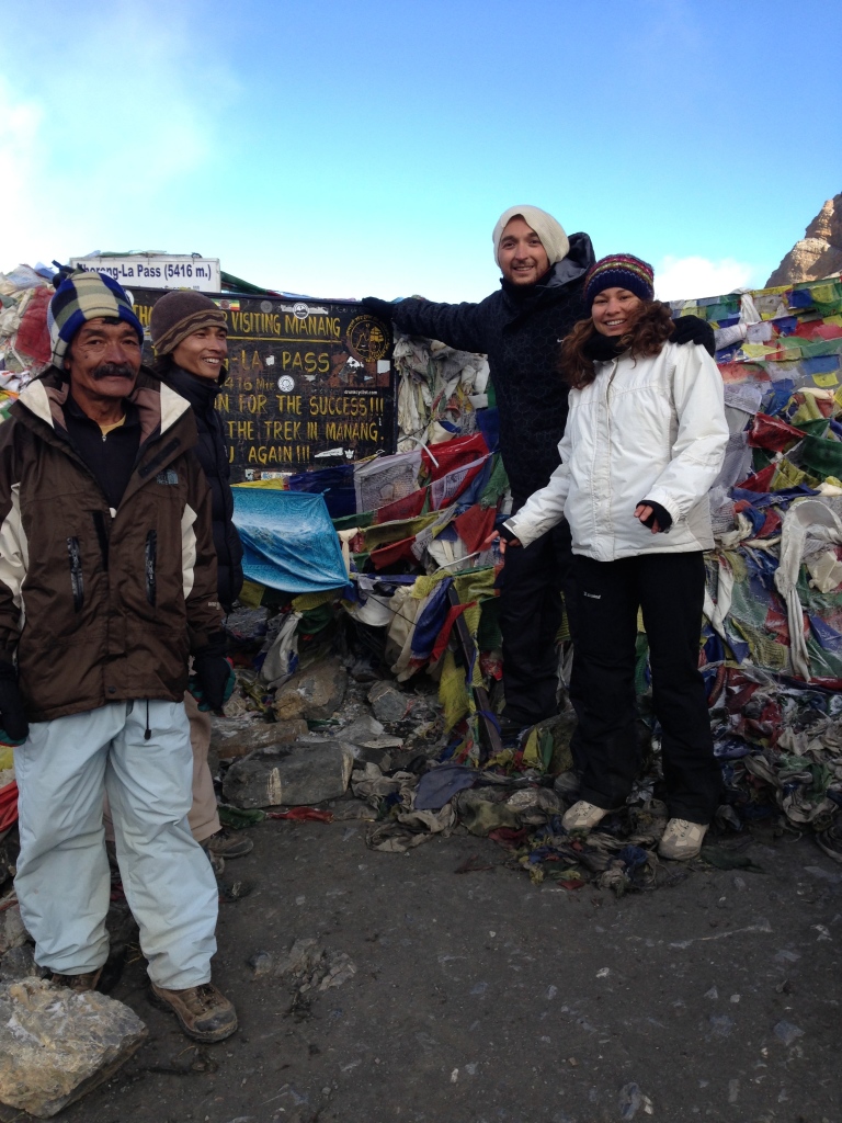
Day 10 - Concurring the Thorung La Pass!
24.09.2014
Trekking and Climbing from Thorung Phedi (4400m) via Thorung La Pass (5416) down to Muktinath (3716m)
- Elevation: 1000m + , 1700m -
- Duration: 2h 40min climbing up to Thorung La Pass - 3h 50min trekking down to Muktinath
- Distance: 25 km
- Accommodation in Muktinath: Muktinath Guest House - I don't know if the food was so amazing or we were so exhausted and hungry that everything tasted so good.
The hotel has small rooms and poor toilet. The bathroom is literally in the dining room, which means you are walking with the towel on you among people who are eating.
There is Wi-Fi, so you can get in touch with your friends and family after the couple days you've spent in the wild. - The town/village: Big village/town, home of the one of the three high Hindu temples. Busy with trekkers and finally a village where you can connect to the internet.
Many of the westerners are speeding their night and free time in the Bob Marley hotel, so if you want to escape the locals this is the place to be.
For us, trekking the Annapurna circuit was more than a just a hike, we enjoyed meeting the locals and learning about the Himalayan culture. - Food:
- Breakfast in Thorung Phedi: Muesli with milk and boiled eggs.
- Lunch in Muktinath: Dal Bhat.
- Dinner at Muktinath: Burrito & Mo: Mo's.
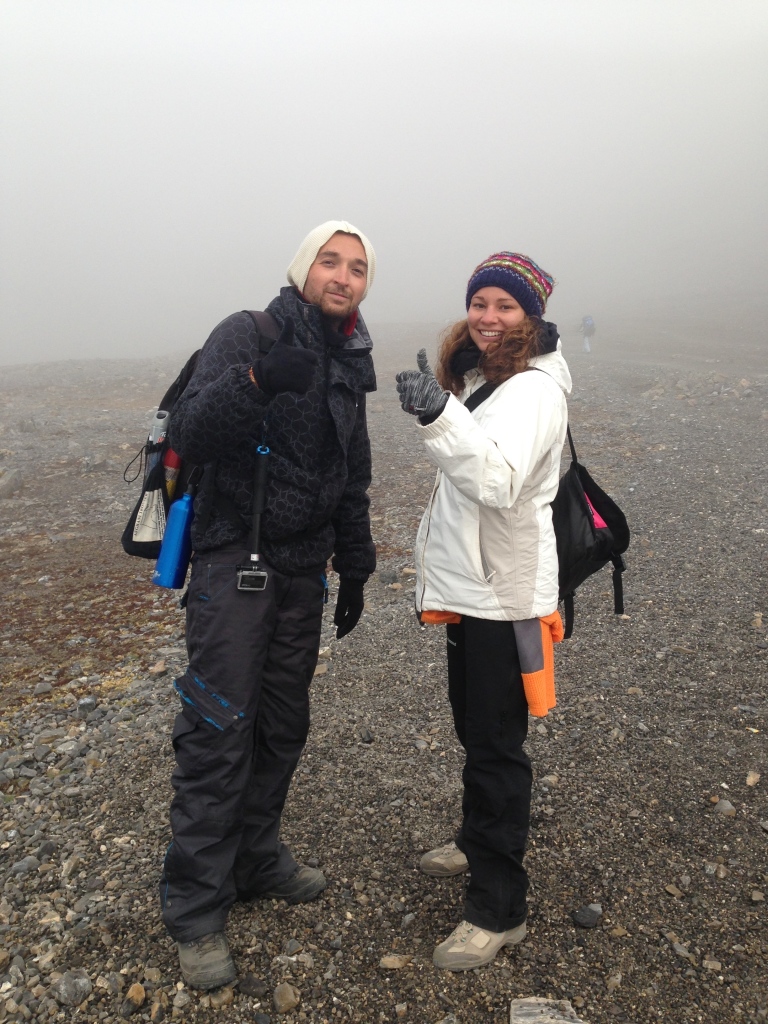
- Highlights: The best day in our lives! We started our climbing in 3:00am with head lamps and all the warm clothes we had. Total darkness spiced with freezing wind, rocks, reduced air, silence ... we were fighting with those conditions while climbing towards the pass.
We were the first group doing the trail from the lower camp to the upper one because the other teams decided to wait for the sunrise. Well rested and full with energy (thanks to the experience of our guide) we managed to caught up with the other trekkers that spent the night in the upper camp and later even lose them behind.
Their problem with lack of energy and sleep was because they spent the night in the higher camp on higher altitude pressure, even after our guide told them that is not recommended for people not used to climbing to sleep that high above sea level. They had problems with altitude sickens and headache.
We were the first to arrive at the pass, we had the place just for us. Photographing, taking videos, laughing, jumping and crying of happiness.
Our guide was also super excited because he had broke his own record in reaching to the pass from the lower camp. Up there was freezing cold, our fingers were freezing while we were taking photos, but we have decided that we gonna wait for the other trekkers so we can make a group photo.
Just before we froze to death we decided its time to enter the Mustang district and continue on our path towards the village of Muktinath.
So difficult ... we would climb anywhere, give as any terrain, we are not afraid ... but walking downwards on a trail that is sandy, slippery, narrow, steep, is the most difficult part of the trekking.
Our feet were destroyed, our toe nails were dark like somebody hit them with a hammer, our knees were ready to dislocate from the legs ... but it was worth it.
The scenery was amazing, white peaks, dry brown mountains, strange bushes, clouds passing trough you, strong winds, something that you can see only in the movies. But then you arrive at the village filled with happiness and can't wait to remove the boots and all the other warm clothes.
You can't wait to get the Wi-Fi and call everybody you love to tell them about your achievement ... we would do it again! - Landscape: Rocky cliffs, White peaks, dry land.
- Climate: Mist, Clouds, Strong freezing wind, - 15 degrees celsius, Sun when approaching Muktinath.
- Clothing: All the winter clothes you have.
- Animals: Horses.
- Difficulty: 10 of 10
Important Tips: Spend the night in the lower camp, start climbing earlier, prepare the head lamps, don't forget the gloves, the sun cream and the lip balm. Have at least 2L water per person. Don't breathe trough your mouth. Prepare for a 3.5h long walk down (1700m) in the worst terrain ever. Have some muesli or boiled eggs for breakfast.
Photography tips: We had only the GoPro and the iPhones with us that day, for the selfies at the top and the quick snaps and videos of the landscapes that were not hidden by the clouds. You will be climbing in the dark so you camera will be of no use, it will just be a burden on your neck. We would recommend to keep it in the back pack, but in the end, it is your choice. After the pass, if the weather is nice and you have clear sky, you can use it for the Mustang landscapes, dry hills and amazing small cloud forms.
Day 11 - While trekking the Annapurna circuit you will experience Sand Storms
25.09.2014
Trekking from Muktinath (3716m)to Kagbeni (2800)
- Elevation: 916m -
- Duration: 4h
- Distance: 8 km
- Accommodation in Kagbeni: Shree Muktinath Hotel - Finally attached bathroom! It was okay, we can't say it wasn't, our only problems was that the hotel is over crowded with flies, we had problem eating because of them, but after 11 days you are getting used to anything, plus you are in Nepal for an adventure, well this is part of it.
- The town/village: Town of the dead! As we were entering the village we had the feeling that we are part of the "Walking Dead" tv show. You will find the locals in the village center where there is a German Bakery. At the end of the village you can see the path to the Upper Mustang. The village has some old architecture which is getting replaced by modern as the trek is getting more popular.
- Food:
- Breakfast in Muktinath: Tibetan bread with boiled eggs.
- Lunch in Kagbeni: Pizza, French fries, sweet and sour rice.
- Dinner at Kagbeni: Thukpa (Tibetan soup)
- Highlights: When you are in Muktinath you must visit the Hindu temple, one of the three most important temples in the Hindu religion. Two are in Nepal (Muktinath & Kathmandu) and one in India.
On the trek to Kagbeni you will enjoy in the amazing dry Mustang mountains where you gonna see caves for which our guide didn't know much, you will experience sand storms along the road and see many locals traveling from somewhere to ... somewhere. - Landscape: White peaks, dry hills.
- Climate: Sun, Strong wind playing with the sand and giving you problems.
- Clothing: Light sweater, shorts, cap and sunglasses. Something to cover your mouth and nose.
- Animals: Horses, Falcons.
- Difficulty: 7 of 10
Important Tips: You will have problem with the strong wind along the trek. Because of the sandy path, the wind is creating small sand storms, so make sure that you have something to cover your nose and mouth.
Photography tips: Landscape lovers will have lots of work, especially if they are fascinated by the dry nature of Mustang. Also for those who like to take photos of people and traditions this day will be fun.
You will see many locals traveling in their traditional clothes carrying bags and boxes on their heads, i found them very inspiring and had luck because their were polite and more than happy to pose for the camera. I was using my Canon with the 50mm 1.4f , my GoPro and my iPhone.
Day 12 - Trekking the Annapurna Circuit ends in Jomsom
26.09.2014
Trekking from Kagbeni (2800m)to Jomsom (2600)
- Elevation: 200m -
- Duration: 2.5h
- Distance: 6 km
- Accommodation in Jomsom: Neeru Guest House - Now is everything ok, we had attached bathroom, clean room, nice food. The same things you get in Kathmandu, plus there are millions of flies again.
- The town/village: Big, boring, nothing to see town. Bunch of guest houses near the airport. The only thing that we did in this town was visiting the museum where you can see exhibit of the snow leopard.
We had canceled flight so we spent 2 days in Jomsom but the second day we went to the village of Marpha which has more to offer. Nice Buddhist temple, "shopping street" with well preserved old architecture. The distance between Jomsom and Marpha is 7.5km, so be prepared for 15km walk if you plan to visit this village. - Food:
- Breakfast in Kagbeni: Pancakes & English Breakfast.
- Lunch in Jomsom: Dal Bhat.
- Dinner at Jomsom: Mo: Mo's, Chow Mein, Veggie Soup.
- Highlights: The amazing walk along the Gandhi river bank where you can find fossils (we didn't, but you can buy them everywhere for 3-4$), while trekking towards Jomsom you have an amazing view of the Nilgiri Himal peak.
- Landscape: White peaks, dry hills, trees!
- Climate: Strong sun, cold wind.
- Clothing: Light sweater, shorts, cap and sunglasses. Something to cover your mouth and nose.
- Animals: Donkeys and cows.
- Difficulty: 5.5 of 10
Important Tips: Again the problem with sand winds, so cover your mouth.
Photography tips: You will have more people and villages, so you can spend some time there to explore and hang out with the locals. Great for portraits and creating photo stories. The river bank will inspire the landscape photographers for creating something new.
Stay in touch on Instagram, Facebook, Twitter & Pinterest
Trekking the Annapurna circuit was organized by our guide and friend Gyan Khand Thakuri and his company All Trekkers Team (P) LTD . Thanks!